Arya News - The Nepal-Tibet disaster serves as a warning for Bhutan, as mountain floods can strike without local rainfall and destroy the instruments meant to alert communities.
THIMPHU – Nepal’s recent flood has demonstrated that rain need not fall where people live for floodwaters to reach their homes, a risk Bhutan must also prepare for.
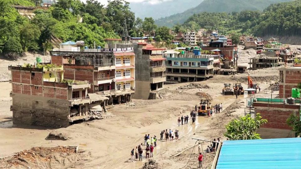
On August 26, a collapse of glacier ice and rock unleashed flooding along the Nepal–Tibet border. Preliminary accounts describe debris blocking the Lhende River before water and sediment surged downstream. Reports of dry conditions at affected locations revealing how a mountain flood can strike without a downpour over the settlements in its path.
By August 28, more than 547 deaths had been reported, with over 1,500 people missing. The figures remained provisional as rescuers searched settlements and authorities monitored newly formed lakes.
For Bhutan, the disaster raises a critical question. If ice collapses above a remote valley, how much time will people below have to reach safety?
“We are in the Himalayas, so the type of flood that happened in Nepal could also happen in Bhutan due to our topography and geography,” an official from the National Centre for Hydrology and Meteorology (NCHM) said. “But where and how it will happen is the question, and we do not know.”
The official said steep slopes in high-altitude areas such as Lunana leave Bhutan exposed to ice collapses. Satellite images and weather monitoring help assess conditions but cannot precisely establish how hazardous an avalanche will be.
Bhutan has already experienced the warning
On October 30, 2023, Thorthormi Lake in Lunana partially breached, releasing about 1.98 million cubic metres of water, according to NCHM’s rapid assessment. Investigators considered ice movement a possible cause of glacier disintegration and the resulting wave.
The flood damaged the automatic water-level station and washed away a footbridge. NCHM temporarily restored the station and recommended additional sensors, improved warnings, lake-depth measurements, and the relocation of vulnerable households facing short warning times.
A 2026 study of the 2019 and 2023 Thorthormi floods found that residents relied on environmental signals and calls from friends and relatives. Sirens did not activate for different reasons: the 2019 flood remained below activation thresholds, while the 2023 wave destroyed the lake’s automatic sensors.
These experiences show that effective warnings depend on more than equipment. Flood levels must be detected, instruments must survive, and information must reach people with enough time to act.
What Nepal’s experience reveals
Nepal had monitoring and warning arrangements, but stations were lost, and some alerts followed reports of flooding.
According to a flood forecasting division technical report, the Bhotekoshi–Syafrubesi station stopped transmitting at 8:50am. Its last recorded water level, ten minutes earlier, was below the warning threshold.
Officials received flood reports at 9am, and mass warnings followed around 9:15–9:16am. The report records 679,295 SMS messages sent and says warnings saved lives. Four monitoring stations were washed away.
Communities near the source faced flooding before mass alerts, while warnings could still help those farther downstream. Establishing what happened at individual settlements requires examination of instrument records, alert logs, and survivors’ accounts.
For Bhutan, the experience highlights the need for warning networks that can continue functioning when floods damage stations or disrupt communications.
Beyond the weather forecast
NCHM updates weather forecasts four times daily. These help identify rainfall hazards but cannot predict when a glacier or mountainside will collapse.
Ice or rock falling into a lake can displace water over its barrier. Landslides can also block rivers, creating temporary reservoirs that later fail. Glacier retreat and thawing frozen ground can contribute to these hazards, although triggers vary between sites. The precise contribution of climate change to the August collapse remains under investigation.
The International Centre for Integrated Mountain Development reports that the Hindu Kush Himalaya, which includes Bhutan and Nepal, warmed by about 0.28°C per decade between 1951 and 2020. Glacier mass loss accelerated by about 65 percent between the decades assessed.
Bhutan’s 2026 Glacier Inventory identifies 673 glaciers covering 571.86 square kilometres, compared with 700 covering 629.55 square kilometres previously. Glacier area declined by 9.16 percent over nine years. Counts alone do not fully explain the change because glaciers can fragment as well as disappear.
A separate glacial lake inventory records 620 lakes, up from 567 in 2021. Their mapped area increased from approximately 55.04 to 58.18 square kilometres.
NCHM identifies 17 potentially dangerous glacial lakes, down from 25 previously. However, neither an increase in lake numbers nor a reduction in those classified as potentially dangerous establishes the overall level of risk. Surrounding slopes, barriers, outlets, avalanche paths, and downstream settlements also matter.
The gap between sensors and safety
NCHM has early warning systems in the Punatsangchhu, Mangdechhu, and Chamkhar Chhu basins and aims to extend coverage across all river basins.
The Punatsangchhu and Mangdechhu systems rely primarily on satellite links to transmit data. Systems in other areas, including Thimphu and Amochhu, use mobile networks.
Limited coverage around high-altitude lakes and weak signals in deep valleys can prevent monitoring stations from transmitting information in real time.
The official said parts of Lunana downstream of the lakes have connectivity, but extending coverage across the lakes and glaciers would improve monitoring.
NCHM favours mobile networks as the primary service where infrastructure allows, with satellite communications as backup. Satellite services carry high recurring costs, the official said.
Ageing equipment also requires continued attention.
“There are early warning systems in place, but some are old and have been experiencing problems,” the official said. “However, they are still under operation, and we are consistently rehabilitating and sustaining them despite financial and technical resource constraints.”
The official said NCHM and the Ministry of Finance, in collaboration with the United Nations Environment Programme, are developing a USD 22 million proposal under the Green Climate Fund to strengthen the country’s nationwide early warning system
“Having sensors and equipment alone doesn’t mean an early warning system,” the official said. “It has to be an end-to-end system, from observation and forecasting to understanding potential impacts, communicating warnings, and ensuring communities are prepared to act.”
In November 2025, the World Meteorological Organisation and the United Nations Office for Disaster Risk Reduction reported that 119 countries had multi-hazard early warning systems. Gaps remained, including for glacial lake outburst floods.
National coverage figures, however, cannot establish whether every exposed settlement is protected. In Bhutan, effective warnings depend on how instruments, communications, and evacuation arrangements work in individual valleys.
Climate talks and support for Bhutan
Bhutan has reaffirmed its commitment to remain carbon neutral, meaning it absorbs at least as much carbon dioxide as it releases.
At COP30, Bhutanese delegation highlighted the rising costs of climate change for countries that have contributed little to global warming and have limited resources to respond.
COP stands for Conference of the Parties, the annual United Nations climate conference where countries negotiate climate action. COP30 took place in Belém, Brazil, in 2025.
The conference called for efforts to triple adaptation finance by 2035. This funding helps communities prepare for and cope with climate impacts. In Bhutan, it can support flood warning systems, safer infrastructure, and water supplies.
Countries also adopted the Belém Adaptation Indicators to track progress in preparing for climate impacts and called for another dialogue on mountains and climate change.
UNEP estimates that developing countries will need between USD 310 and 365 billion annually for adaptation by 2035. International public adaptation funding stood at USD 26 billion in 2023, down from USD 28 billion in 2022.
Loss-and-damage is another global fund which support addresses impacts that cannot be avoided or have already occurred, including destroyed homes, lost livelihoods, and damaged farmland.
Preparing for future floods
The NCHM official said Bhutan plans to rehabilitate and enhance ageing warning systems and extend coverage across its river basins. This includes maintaining equipment, improving communications, and helping communities understand warnings and practice evacuation.
Monitoring glaciers, lakes and surrounding slopes can help identify potential hazards. Yet communities close to a flood’s source may have little time to move.
NCHM’s recommendations after the 2023 Thorthormi flood included relocating vulnerable households. Such moves require consultation and arrangements for land and livelihoods.
“The lesson from Nepal is not that the same disaster will happen in Bhutan,” the official said. “The lesson is that Himalayan hazards can develop quickly, and we must be prepared even when the warning time is short.”